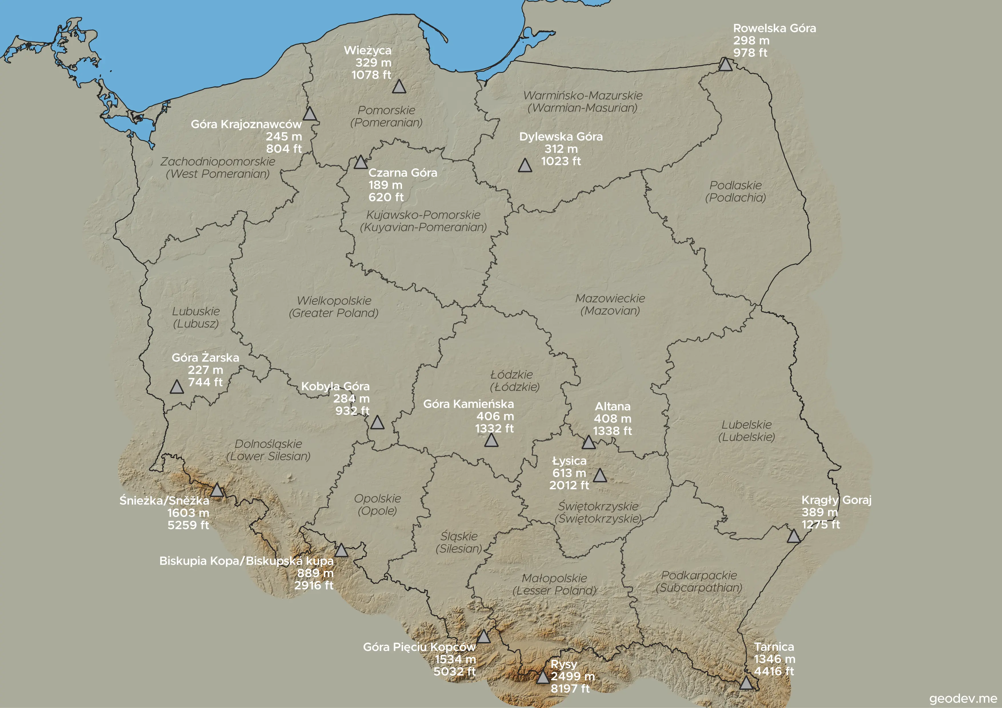
This map presents the highest peak of every voivodeship in Poland (województwo - highest-level administrative division of Poland).
The peaks are diverse, ranging from the low-lying hills of northern and central Poland to the towering mountains in the south. The lowest highest point is Czarna Góra in the Kuyavian-Pomeranian Voivodeship, at a 189 meters, while the highest is Rysy in the Małopolskie Voivodeship, reaching 2,499 meters.
The highest elevations are concentrated in southern Poland. The peaks in this region include:
- Rysy (Małopolskie) is part of the Tatra Mountains.
- Śnieżka (Dolnośląskie) is in the Karkonosze Mountains.
- Góra Pięciu Kopców (Śląskie) is in the Silesian Beskids.
- Tarnica (Podkarpackie) is in the Bieszczady Mountains.
In contrast, the northern and central voivodeships feature much lower peaks, which are primarily hills or moraines left by glaciers. Examples include Dylewska Góra (Warmińsko-Mazurskie) and Wieżyca (Pomorskie), which are part of the post-glacial landscape.
The table with data:
| # | Name | Elevation (m) | Elevation (ft) | Voivodeship |
|---|---|---|---|---|
| 1 | Czarna Góra | 189 | 620 | Kujawsko-Pomorskie |
| 2 | Góra Żarska | 227 | 744 | Lubuskie |
| 3 | Góra Krajoznawców | 245 | 804 | Zachodniopomorskie |
| 4 | Kobyla Góra | 284 | 932 | Wielkopolskie |
| 5 | Rowelska Góra | 298 | 978 | Podlaskie |
| 6 | Dylewska Góra | 312 | 1023 | Warmińsko-Mazurskie |
| 7 | Wieżyca | 329 | 1078 | Pomorskie |
| 8 | Krągły Goraj | 389 | 1275 | Lubelskie |
| 9 | Góra Kamieńska | 406 | 1332 | Łódzkie |
| 10 | Altana | 408 | 1338 | Mazowieckie |
| 11 | Łysica | 612 | 2012 | Świętokrzyskie |
| 12 | Biskupia Kopa | 889 | 2916 | Opolskie |
| 13 | Tarnica | 1346 | 4416 | Podkarpackie |
| 14 | Góra Pięciu Kopców | 1534 | 5032 | Śląskie |
| 15 | Śnieżka | 1603 | 5259 | Dolnośląskie |
| 16 | Rysy | 2499 | 8197 | Małopolskie |
Made with QGis 3.